
Center for Problem-Oriented Policing
Step 24: Know when to use high-definition maps
Conventional software is of little use when mapping crime in a downtown area, a college campus, a public housing project, or any site with many large buildings. This is because most buildings, however large, have only one street address, and crimes occurring anywhere in the building are assigned to that address. Mapping might therefore suggest that a particular building or facility has a crime problem, but this may only be because it is so large. When account is taken of the many people working in the building or using the facility, it could prove to be relatively safe. For example, George Rengert showed that a parking garage in central Philadelphia identified as an auto crime hot spot actually had a lower rate of auto crime than the surrounding streets, once account was taken of the large number of cars that could be parked in the facility.
In fact, many large buildings are not safe. In his devastating critique of 1960s American public housing, Oscar Newman showed that the taller a tower block, the higher the rate of crime per 100 residents. He argued that very large blocks invited crime because residents did not know their neighbors and the design and layout of the buildings made it difficult for them to exercise any supervision of the public spaces, including corridors, elevators, and play areas. His ideas have since been developed into a set of principles - Crime Prevention through Environmental Design (CPTED) - for designing and laying out secure buildings and public spaces.
To understand why a particular building is insecure, crimes need to be divided into specific categories and their locations within the building need to be charted. This is where high-definition or 3-D mapping comes into play. Unfortunately, high-definition mapping is difficult and time consuming. It suffers from two principal problems:
- Police records of crime rarely give the precise location of incidents within the building, though building managers or security departments can sometimes supply this information. When they cannot, special crime-recording procedures may have to be established for a period of time in order to obtain this information (Step 21).
- For new buildings, it may be possible to obtain plans in digitized format, which can make mapping easier. But when the building is old, it may be difficult to obtain up-to-date plans so you may have to get these drawn.
In many cases, these problems will simply rule out high-definition mapping, but they can be overcome, as George Rengert and his colleagues showed in their study of crime on Temple University's campus in Philadelphia. They developed a high-definition GIS by combining mapping software with AutoCAD drawings of the campus. Features such as water pipes and electrical wiring were eliminated, and the maps were altered so that streets were represented as lines (with lines on either side representing pavements), while polygons were used to represent the footprints of buildings and the shapes of athletic fields and parking lots. Shrubbery, fences, lighting, and other physical features were also represented on the maps. Crimes recorded by the campus police were then plotted exactly where they occurred, allowing them to be related to environmental features such as poor lighting or a blind corner allowing the attacker to lie in wait.
Crime was mapped for the floors of each building and a picture of the horizontal arrangement of crime within the building was projected onto its ground floor footprint. Figure 1 shows the result for one of the buildings -Gladfelter Hall. Crime is distributed among all floors, with the exception of the 10th floor. The map also shows a clear cluster of crime common to most floors, the area closest to the bank of four elevators near the center of the building. This is where each academic department's fishbowl offices for secretaries and receptionists are located - fishbowls because they are surrounded by glass windows, which allow thieves to look into them to see if anyone is there and if anything is worth taking. The Department of Criminal Justice - Rengert's own department - has now installed blinds, which can be lowered in the evenings to prevent people seeing into the fishbowl.
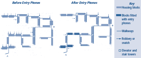
Commercial software is already available that will produce photo-realistic city models, and technological developments, such as 3-D laser imaging, will simplify the production of computer maps like those of Gladfelter Hall. Meanwhile, when the number of incidents is small, good clear drawings with the location of crimes clearly indicated can sometimes do just as well. Figure 2 is a plan of the Lisson Green public housing estate in London, drawn by Barry Poyner, showing the locations of robberies and purse snatches on the walkways connecting the buildings for two 6-month periods: before any preventive changes were made and after four of the blocks were fitted with entry phones. In effect, the entry phones closed access to the walkway system from the main street entrance. In this case, high-definition mapping assisted with the assessment of preventive action. But Figure 2 also helped with diagnosis of the problem because it showed that robberies and purse snatches tended to occur on those parts of the walkway system that lacked surveillance from neighboring buildings or ground level.
Figure 1: 3-D Map of Gladfelter Hall, Temple University Campus
High Definition Geographic Information System
![Gladfeiter Hall, Temple University [map]](/sites/default/files/graphics/step_24a.gif)
Figure 2: Locations of Robberies and Snatches on the Walkway System on the Lisson Green Estate
Read More
- Crowe, Tim (1991). Crime Prevention Through Environmental Design. Applications of Architectural Design and Space Management Concepts. Boston: Butterworth-Heinemann.
- Rengert, George, Mark Mattson, and Kristin Henderson (2001). Campus Security. Situational Crime Prevention in High-Density Environments. Monsey, NY: Criminal Justice Press.