
Center for Problem-Oriented Policing
Step 27: Know how to use rates and denominators
When one place has more crimes than another place, one possible reason is that one has more targets than another. Examining rates helps you understand if number of targets contributes to your problem (see Step 17).
Rates describe the number of crimes per target at risk, during a period of time: one burglary per 1,000 households during 2002, for example. Target rates show the risk the average target has of being involved in a crime during the time period.
To calculate target rates you will need to:
- Define the type of event you are interested in (e.g., thefts from vehicles).
- Define the at-risk population (e.g., vehicles).
- Define the locations and time period (e.g., downtown area parking lots in 2004);
- Find sources of data that that provide counts of events of interest and targets for each location being examined (e.g., police reported crime data has information on address of theft, which can be associated with specific parking lots, and observations of downtown parking lots can provide estimates of the number of vehicles in each lot).
- For each location, divide the number of events (the numerator) by the number of targets (the denominator) to obtain rates.
Defining the targets at-risk requires careful thought. If you are analyzing burglaries, is your target people or homes? "Homes" is the more reasonable answer. Everything being equal, if a population of a 1000 people lived in 500 units we would expect it to have more burglaries than if the same population lived in 250 units. If you are analyzing street robberies, then the at-risk population is the number of pedestrians in the area being examined.
Police incident reports usually contain data describing the events of interest, including address information, so counts of events at locations can be obtained. However, it is often difficult to obtain information describing the number of targets at risk at locations. For example, reported thefts from vehicles may be available for parking lot addresses, but the number of vehicles using the lots may not be readily available (see box).
To overcome this problem, you might have to find proxy measure of targets. The number of vehicles using parking lots, for example, may be proportional to lot size. Thus, a proxy measure for vehicles at risk might be square footage or number of parking spaces. The table gives some examples of estimating at-risk target rates.
Proxy measures of targets must have two characteristics. First, they must be logically associated with the targets. One would expect spaces to be associated with the volume of vehicles, but we would not expect number of feet of parking lot street frontage to be associated with number of vehicles, because very deep lots could have little street frontage but contain many vehicles. Second, the association between the proxy and at-risk targets cannot vary too greatly across locations. If all parking lots in the downtown area are about two thirds full during the week, number of spaces is a useful proxy. But if some lots are used to capacity and others get little use, then number of spaces is not a good indicator of targets.
Example of Rates for Different Crimes
| Type | Location | Rate | Comments |
|---|---|---|---|
| Apartment burglaries | Apartment buildings | Burglaries per apartment, or per household | Burglaries per resident places too much emphasis on large families. |
| Shoplifting | Retail stores | Thefts per item on shelves, or per square foot of retail space | Thefts per customer gives an offending rate. |
| Motorcycle Theft | Neighborhood | Motorcycle thefts per registered motorcycle | Problematic for areas cyclists use but do not live in. |
| Graffiti | Commercial areas | Graffiti per square foot | Difficult to measure. |
| Taxi robberies | Company | Robberies per cab, or per driver, or driver-hours | Hours of exposure is preferable, but data may not be available. |
| Disorder calls from motels | Motels | Disorder calls per guest or per room | Might also look at numbers of non-guest visitors. |
Even with proxy measures, it can be difficult to obtain target data. Government agencies might have some of the information you need. For example the Hamilton County, Ohio, auditor has information on every land parcel in the county, including the square footage and location. Businesses and business associations sometimes have information about sales volume. And state supplied sales tax information can be used as proxy for the numbers of customers (when comparing stores selling similar items).
Calculating rates can be very helpful in finding risky facilities (Step 28). Karin Schmerler and her colleagues in the Chula Vista, California, Police Department investigated calls from the city's motels. The 10 national chain and 16 local independent motels generated similar numbers of calls, but the national chains contained more rooms.
When they added up all the calls for the local independents and divided this by the rooms in these motels, Schmerler found that the average call rate for the independent motels was 1.8 per room. Doing the same for the national chains yielded a call rate of 0.5. Clearly, the local independents generate many more calls per room.
Should you put more emphasis on high numbers or high rates? If your objective is to reduce the volume of crime, then focusing on numbers may the best choice. But if your objective is to reduce the chances of harm, then focus on rate.
Using Rates to Identify Risky Parking Lots
Rates of theft from cars by block, Charlotte NC, 1999
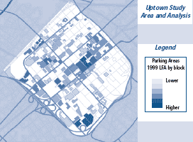
The value of calculating rates is illustrated by a project in Charlotte, North Carolina on which one of us (Clarke) worked with Herman Goldstein. Assisted by local analysts and police officers, we examined larcenies from autos (LFAs) in parking facilities in the downtown area of the city (locally known as Uptown). Hot spot analysis had shown a large undifferentiated cluster of these thefts centered in the middle of the area, but a map based on rates of theft was far more revealing. This map was produced by crime analyst Matt White, who enlisted the help of precinct officers in counting the number of parking spaces in each facility. He then calculated theft rates for each lot and parking garage. The resulting map revealed a much more detailed picture of risk. Further analysis showed that cars parked in lots were six times more at risk than ones in garages and that some lots were crime enablers due to inadequate security.
Read More:
- Clarke, Ronald and Herman Goldstein (2003). "Thefts from Cars in Center City Parking Facilities." From Innovation to Mainstream. Crime Prevention Studies, vol. 15, Monsey, New York: Criminal Justice Press. (available at: www.popcenter.org)