
Center for Problem-Oriented Policing
Step 55: Make clear maps
Maps have an important role in telling compelling stories about problems. But they need to be clear to accomplish this. That is, maps must contain as much relevant information as possible and no irrelevant information. There are a number of guides to good cartographic principles available (see box and Read More).
We will illustrate the use of maps to tell stories with a set of maps from a problem-solving project undertaken by the Norwegian Police. Figures 1 and 2 illustrate how maps can be used to describe problems and solutions. Johannes Knutsson, of the National Norwegian Police Academy, and Knut-Erik Svik, of the Vestfold Police District, were attempting to address a problem of illegal ("gypsy") cabs in a small coastal town of Tønsberg (population 36,000). On weekends the 30 drinking establishments draw large crowds and people move back and forth across a highway, so the highway is closed on Friday and Saturday nights. A parking area is also closed. However, legal taxis and busses can move along the highway. Unlicensed "gypsy" cabs have taken over most of the business in this area, in part by intimidating the licensed cab operators. A number of serious crimes had been attributed to the drivers of these illegal cabs and they have been the subjects of numerous complaints.
The setting of the problem is shown on two maps in Figure 1. The left panel is a street map. It shows many features irrelevant to the problem and fails to show many features that are important. The right panel is a highly edited version of this map. It contains only the relevant features of the base map and adds the important omitted features, giving a much clearer picture of the setting.
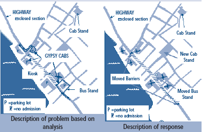
Figure 2 contains two maps summarizing conclusions from the analysis and important features of the response. The left map shows the primary travel routes of the gypsy cab drivers. The gypsy cabs make use of the street barricades and the parking lots to pick up customers. This map also shows that the bus stand and (legal) cab stand are too far from the people using the area. When the bars close after 3:00 AM there is great demand for transportation and the illegal cabs are in the best position to fill the demand. The response map on the right of Figure 2 shows how the highway barrier was moved to prevent gypsy cabs from getting to potential customers, the parking lots blocked off late at night to keep these cabs out, and how the legal cab stand and bus stand were moved to locations more convenient for the customers. This map is an important part of the process evaluation (Step 46).
Together, these three maps nicely illustrate the nature of the problem and what was done about it. The result of this project was the virtual elimination of the gypsy cab problem in Tønsberg, without increasing disorder.
Knutsson and Svik heavily annotated these maps to show features that a typical geographic information system would not show. This is good practice. Much information about problems is not contained in computers.
Still, there are a number of features of good maps that are missing. There is no compass direction. However, direction plays no part in the problem so its absence does not detract from clarity of the maps. Also missing is a scale showing the relative size of map features. This impedes understanding of those who are unfamiliar with the area.
Creating Useful Maps
- Know what information your audience will find useful (and what information is confusing).
- Keep maps simple. Eliminate all features that do not contribute to understanding the problem.
- Avoid graphics that draw more attention to themselves than the data.
- Include details that help the viewer understand the problem, even if that means adding this information by hand.
- Include a scale and, if needed, a compass orientation (usually North is to the top).
- Use meaningful gradations to show intensity of hot spots. For example show colors becoming increasingly hot (yellow to red) as the problem worsens.
- Apply the correct dimension of crime concentration: dots for places (and sometimes victims); lines for concentrations along streets and highways; and areas for neighborhoods.
- Make use of tables and figures along with maps.
Figure 1: Locating the Problem and Showing Its Setting
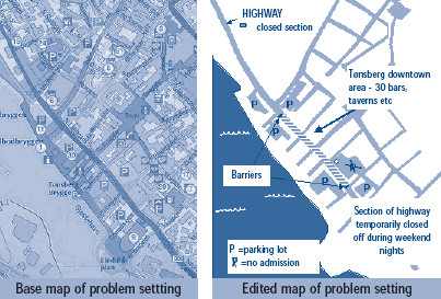
Figure 2: Analyzing the Problem and Showing Response
Read More
- Boba, Rachel (2005) Crime Analysis and Crime Mapping: An Introduction. Thousand Oaks, CA: Sage Publications.
- Harries, Keith (1999). Mapping Crime: Principle and Practice. Washington, DC: National Institute of Justice, Crime Mapping Research Center.
- Knutsson, Johannes and Knut-Erik Svik (2004) Gypsy Cabs in Tønsberg. Submission to the Herman Goldstein Awards. (accessible at www.popcenter.org)
- Jerry Ratcliffe has a list of mapping tips at: www.jratcliffe.net