by Diane Zahm
Translation(s): O uso da Prevenção Criminal Pela Conceção Ambiental (Portuguese) PDF
Crime prevention through environmental design (CPTED) is an approach to problem solving that asks, what is it about this location that places people at risk, or that results in opportunities for crime? In other words, why here? Three case examples will illustrate this point:
Case #1: Custodial workers routinely find evidence of smoking, drinking and vandalism in a high school lavatory.
Why here? The lavatory is in an isolated area of the building, adjacent to a ticket booth and concession stand that are active only during athletic events. The school's open lunch policy allows students to eat anywhere on campus, while monitors are assigned only to the cafeteria.
CPTED response: A lock is installed on the lavatory door, and it remains locked unless there is an athletic event. The open lunch policy has been revised: students are still allowed to leave the cafeteria but must eat in designated areas, and a faculty member is charged with patrolling these areas during lunch periods.
Case #2: The back wall of a building in an office center is repeatedly tagged with graffiti.
Why here? The taggers have selected an area that is out of the view of passers-by: a rear corner location where two buildings come together at the end of a poorly lit service lane. Visibility is further reduced by hedges at the site’s perimeter. Businesses in the office center are open from 9 AM to 5 PM during the week; however the tagged building is next to a roller skating rink where activity peaks at night and on weekends.
CPTED response: Hedges are trimmed and wall-mounted light fixtures installed along the service lane, with motion detection lighting in the problem area. The skating rink agrees to change to a “no re-admission” policy to keep skaters inside the building and away from the office property.
Case #3: ATM patrons at a bank are being robbed after dark.
Why here? The bank is situated along a commercial strip in a neighborhood with vacant properties and abandoned businesses. The ATM is in the front corner of the bank building, and the drive-through teller windows are at the side of the building, around the corner from the ATM. Robbers hide in the darkened drive-through teller area and attack unsuspecting ATM users after they complete a transaction.
CPTED response: The bank installs a fence at the corner of the building, creating a barrier between the ATM and the drive-through teller area.
In each of these case examples, asking why here? reveals that opportunities for crime and other problems arise out of a variety of environmental conditions related to the building, the site, and the location and how the place is used. Solving a problem thus requires a detailed understanding of both crime and place, and the response should consider one of the three objectives of crime prevention through environmental design: control access, provide opportunities to see and be seen, or define ownership and encourage the maintenance of territory.
This guide is a resource for understanding and using crime prevention through environmental design as a problem-solving tool. The guide explains the basic principles of CPTED and outlines a process for identifying problems, evaluating the physical environment, and identifying strategies that will remove or reduce opportunities for crime.
Crime prevention through environmental design is an approach to problem solving that considers environmental conditions and the opportunities they offer for crime or other unintended and undesirable behaviors. CPTED attempts to reduce or eliminate those opportunities by using elements of the environment to (1) control access; (2) provide opportunities to see and be seen; and (3) define ownership and encourage the maintenanceof territory. †
CPTED is unusual when compared with other crime prevention or security measures because it specifically focuses on aspects of the design, while the other measures tend to be directed at target hardening, i.e., denying access to a target using locks and bars, or using sensors and cameras to detect and identify an offender, supported by security guards. CPTED is unusual also when compared to some police activities. This is because CPTED encourages prevention and considers design and place, while policing has traditionally valued an efficient and effective response to incidents, and the identification and arrest of offenders.
CPTED may be distinctly different from traditional policing, yet it is very consistent with problem oriented policing, in four ways:††
†For a more detailed introduction to CPTED, see Crowe (2000), Crowe and Zahm (1994), and National Crime Prevention Council (1997).
††Herman Goldstein’s book, Problem-Oriented Policing (1990) offers greater detail on these and other aspects of POP.
Crime prevention through environmental design is a relatively new term, but the use of design for safety and security is not. Caves and cliff dwellings, and castles and moats are good historical examples. Requirements for street lighting grew out of a need to distinguish legitimate travelers from outlaws and thieves.
Contemporary approaches, including CPTED, emerged out of research on the relationship between crime and place, theories known variously as environmental criminology, situational prevention, rational choice theory, or routine activities theory, among others.† Each theoretical approach focuses on the crime event and how a criminal offender understands and uses the environment to commit a crime. Like CPTED, this research asks, why here? The research reveals:
† See also Newman (1972), Jeffery (1971, 1977), Brantingham & Brantingham (1981, 1984), Clarke (1980, 1992), Cohen & Felson (1979), and Cornish & Clarke (1986).
Crime prevention through environmental design examines crime problems and the ways in which various features of the environment afford opportunities for undesirable and unwanted behaviors. CPTED attempts to remove or reduce these opportunities by changing various aspects of the building, the site, and the location, and how that place is used.
These changes are directed toward three basic objectives, each of which is described briefly below, including examples of CPTED strategies:
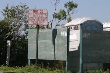
This is exactly how NOT to do CPTED! 1. It is dreadfully ugly; 2. the walls around the portable bathroom make it impossible to observe undesirable and unwanted behaviors. Credit: Ronald Clarke
Examples:
Examples:
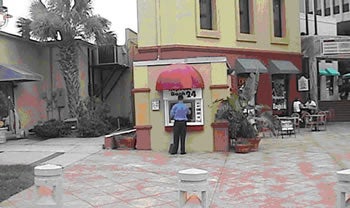
This ATM is placed well, using good CPTED features and has an unobstructed view from the street and patrolling police. Credit: Randy Atlas
Examples:
Note that while CPTED is a crime prevention program, it focuses on design, not safety, and on productive use, not security. Design features are “supported” by locks, guards and alarms. Target hardening and security measures are not the primary means for improvement. Note, too, that although CPTED is frequently considered the responsibility of police, many of the tools and techniques are things that fall outside the purview of policing. This is why CPTED is a team effort, one that officers participate in but do not necessarily control.
The problem-solving process used in crime prevention through environmental design is a series of steps designed to answer four questions:
Each question represents a phase in the SARA process: scanning, analysis, response, and assessment.† SARA serves as a framework for action; and while SARA is a good place to start, the process may need to be modified and adapted to the specific location and circumstances. The actual process depends on a variety of factors. For example, in the case of a very specific crime problem in a single location, the process need not include time to define or refine the problem. Analysis focuses on a single type of crime and, because crime data are already available for the problem site, the analysis can begin immediately.
†For more information, see the description of the SARA process.
Additional time is required as issues become more complex, and impact larger geographic areas and greater numbers of stakeholders. In such instances it takes time to organize a problem-solving team and to collect data. It is also more difficult to find a solution that both addresses the problem and satisfies all stakeholders.
One of the key constraints may be the cost of implementation. Although many CPTED strategies are relatively cost-free and easy to accomplish in a short time frame (for example, changes to policies), other projects may require significant investments of capital and phased implementation over several years.
A general description of the four SARA phases and the steps that might be included as part of a CPTED problem-solving process are outlined in Table 1. Each phase addresses one or more aspects of the environment that are critical for employing CPTED strategies to solve the problem. Additional detail on the process is included in later sections of this guide.
| The Sara Process | Table 1: Problem Solving with Crime Prevention Through Environmental Design |
|---|---|
| SCANNING | 1. Identify, define and investigate an existing or emerging problem. 2. Identify the stakeholders who should be engaged in problem solving. 3. Decide on the combination of meetings and activities that will be necessary for problem solving and create a schedule for working through the process. |
| ANALYSIS | 4. Meet with stakeholders to clarify the problem and to define the goals and objectives for the process. 5. Collect and analyze data and information about the problem. 6. Evaluate any connections or relationships between the problem(s), and environmental conditions. |
| RESPONSE | 7. Establish the goals to be achieved through the implementation of crime prevention through environmental design or other strategies. 8. Identify alternative strategies for achieving the implementation goals. 9. Evaluate the social, political, legal, financial, or technological feasibility of implementing each strategy. 10. Select the most promising strategies, and create and adopt a plan for improvement that identifies specific strategies, defines financial and other resource requirements, assigns responsibility for implementation and oversight, outlines a schedule for plan implementation, and establishes indicators of success. † 11.Put the most promising and feasible measure(s) into place. A combination of immediate responses, short-term improvements, and long-term investment may be required. |
| ASSESSMENT | 12. Monitor progress relative to the indicators of success specified in step #10. 13. Decide if the process needs to be repeated due to lack of progress or the emergence of new problems. |
†In A Manual for Crime Prevention Through Planning and Design, Kruger, Landman and Liebermann (2001) suggest a plan based on (1) urgency or need; (2) the likelihood for success; (3) the potential for positive impacts in other areas; (4) cost; and (5) resource availability.
One unique aspect of using CPTED for problem solving is the array of data and information that must be gathered and analyzed. While crime, fear and victimization are critical considerations, an environmental evaluation needs to include information that is neither law enforcement-based nor related to crime, for example, land use and zoning, housing code or health code violations, or traffic volumes and pedestrian activity. Quality of life issues such as trash and litter, weeds, vacant lots, and declining property values are also considered, as these problems often have a more debilitating impact on a community on a day-to-day basis. They can also be symptoms of, or precursors to, crime.
The purpose of the environmental evaluation is two-fold:
The intricacy of the analysis ultimately depends on three conditions, which are described in greater detail below:
Table 2 considers the various types of information that might become part of an environmental evaluation. Much of the data and information on the list is available from existing sources and agency records; however, significant and necessary pieces of information can sometimes only be obtained through interviews, surveys and observations. Safety audits and security surveys need to be specifically tailored to the facility, the site, or the neighborhood, and in most cases, must be handled by someone who is knowledgeable about locks, lighting, or other aspects of security.
The list of data elements in Table 2 is a general one, and not all of the items will be necessary for every problem-solving activity. The overall goal is to inventory existing conditions and document emerging trends related to a specific problem in a specific location - to answer the question, why here? Four types of scenarios are possible, and each suggests a different kind of data collection strategy:
Data collection and analysis can be a time consuming process, and adequate time is not always available. In some instances, public or other, pressures for an immediate response to the problem will strip away any opportunity for analysis. In such cases, evaluation becomes even more critical, to understand the impact of the intervention and to give greater definition to the original problem or any other issues that emerge as a result of the decision to intervene.
Table 2 is also a reminder that crime prevention through environmental design is best undertaken by a team of departments and individuals in collaboration with community representatives. Experience has shown that CPTED strategies are most effective when those who are impacted by the problem are engaged in problem solving and take ownership for the solution. The entire problem-solving process is enhanced when stakeholders are included early on, for example, by organizing a CPTED task force or by using community volunteers to help with data collection.
Data and Information Commonly Used in an Environmental Analysis |
|||
|---|---|---|---|
| Examples of Information Collected: | Rationale | Source(s), Availability and Responsibility | |
| Crime Data | calls for service reported crime: total crime crime rate crime type crime trends spatial distribution: crime location(s) “hot spots” temporal distribution: times of day days of the week seasonal changes MO (modus operandi, or how the crimes are carried out): target characteristics victim characteristics offender characteristics |
Analysis of calls for service and crime incidents gives greater clarity to the problem and also some direction with regard to the other types of data and information that will need to be collected. |
Crime data is collected and maintained by the police agency (records division or crime analysis unit) or by the locality’s management information systems department. Crime mapping and geographic information systems (GIS) may be the responsibility of the police agency, or may be handled by another department, e.g., p lanning, engineering, or utilities. |
| Population Characteristics | age and gender race and ethnicity family or household size and composition family or household income |
Community characteristics are helpful for thinking about routines and activities and the potential for victimization. They may also suggest a focus for crime prevention programs or other interventions. |
Population demographics are available through the U.S. Census (see www.census.gov), which is regularly updated for larger localities through the American Community Survey. Smaller communities or neighborhoods must be updated using surveys unless another agency has already undertaken this work. |
| Institutional and Organizational Relationships | neighborhood association/homeowners’ association block watch/neighborhood watch group churches, clubs, public/private schools, hospitals, community centers or other neighborhood-based institutions local development corporations and other nonprofits engaged in work in the neighborhood |
Community organizations and local institutions play several roles related to the problem-solving process and the implementation of crime prevention through environmental design strategies:
|
Locating complete lists for community associations and nonprofit organizations is often difficult; however, several opportunities are available. The neighborhood planning unit should maintain a list of neighborhood associations, and the police agency should have information about Neighborhood Watch groups in the community. Information about community centers and other institutions may be found through an Information and Referral Service or an online locator (e.g., www.GuideStar.org). Other options include the local interfaith council or ministerial association, a volunteer center, or the social services department. |
| Land Use and Development Patterns | land use: type and mix of land uses residential buildings/dwelling units office/commercial buildings/spaces or total square feet of leasable space businesses by business type major facilities, landmarks or attractions, e.g., parks, schools property ownership (public/private) natural resources and attractive nuisances, e.g., lakes, rivers, streams, rocks development rules and regulations outlined in zoning, subdivision, landscaping or other ordinances neighborhood stability: housing or building condition tenure (owner-renter mix) occupancy/vacancy rates turnover (new sales, new leases, new vacancies) property values: average rent average sales price assessed value development activity: construction permits demolition permits occupancy permits violations and citations: building code housing code health code |
The mix of uses determines the kinds of activities that take place in a building/site/area, when and where they happen, and who participates in them. Items such as housing condition or turnover do not cause problems, but are symptoms or outcomes of issues. They are indicators of reinvestment or disinvestment in the neighborhood, or a general lack of care, and disrespect for property and community. |
Information on existing land use and future development is the responsibility of the planning department (comprehensive planning unit, long-range planning, zoning administration, development review). Property data is housed with the assessor. Some statistics, such as turnover or average rent, may be gathered from real estate advertisements or local agents. The U.S. Census (www.census.gov) also collects data on housing costs. Business information may be handled by either the planning or economic development departments. Many localities now have online GIS systems that include information on land use, zoning, ownership, assessed value and other property characteristics. The system may be administered by a single person or organization (possibly even a consulting firm), or multiple departments may be responsible for maintaining data related to their areas of responsibility. Permits and violations are handled by zoning administration, codes enforcement, or the public health agency. |
| Traffic, Transportation and Transit Systems | transportation networks: interstate and other highways major intersections local and regional connector routes pedestrian and bike ways (sidewalks, trails, greenways, etc.) site circulation, ingress and egress on- and off-street parking spaces/lots/garages traffic: common origin/destination sites and travel routes daily/weekly volumes peak (rush hour) loads accidents transit system: ridership and user characteristics routes and schedules transit stops/shelters/centers transfer locations neighborhood complaints: speeding cruising loitering |
Patterns of crime and other problems are often related to patterns of movement that bring people to and through sites, neighborhoods, localities and regions. |
Road and traffic information for most localities is a function of the state transportation department. Regional transportation planning agencies should also have this information. Neighborhood- or site-related traffic issues will require new studies, local data collection and observations of traffic flows, turning movements, or other traffic-related activity. The transit company should maintain information on its system and operations. Most complaints are wagered with the police agency. |
| Resident/User Surveys or Stakeholder Interviews † | define and explain the problem (real or perceived) victimization: reported unreported reasons for not reporting fear: where people are afraid why people are afraid schedules and activities during an average day/week/month/season concerns, attitudes, opinions and suggestions about neighborhood quality of life |
Patterns of crime and other problems are often related to patterns of movement that bring people to and through sites, neighborhoods, localities and regions. |
Road and traffic information for most localities is a function of the state transportation department. Regional transportation planning agencies should also have this information. Neighborhood- or site-related traffic issues will require new studies, local data collection and observations of traffic flows, turning movements, or other traffic-related activity. The transit company should maintain information on its system and operations. Most complaints are wagered with the police agency. |
| On-site Observations | problem behaviors: loitering vandalism and graffiti public drinking drug sales or drug use gang activity legitimate play or other activities distribution of activities: when activities are most likely to occur where activities take place user characteristics: age, gender, race/ethnicity resident, owner, staff/employee, patrons, invited visitors, others consistency between reported behaviors and observed activities |
Observations should reinforce the results of surveys and interviews (when the observed activities are consistent with reported behaviors), and should offer support for crime statistics and other data and documentation. |
|
| Safety Audits and Security Surveys | building and site characteristics: floor plans site design and layout ingress/egress, circulation and parking plant materials and landscape elements lighting crime prevention and security measures: locking systems and key control lighting and illumination CCTV security maintenance and repair emergency operations plans security policies and procedures operations: staffing activities and schedules rules, regulations, policies, and procedures |
Audits and security surveys provide details the other sources of information do not, specifically with regard to building or site conditions, target hardening and security measures, etc. They also begin to expose connections between the problem and staffing or policy. Depending on the location and the type of problem, police personnel (crime prevention unit) may be able to train homeowners and business managers to perform their own evaluations. Generally though, when a security survey is warranted, this should be handled by a knowledgeable professional. |
|
† Also refer to the Bureau of Justice Assistance (1993) [PDF] monograph, A Police Guide to Surveying Citizens and Their Environment.
This is a critical point in problem solving because it is time to make decisions about what to do. Stakeholders should be engaged in developing the plan and are likely to have very concrete ideas about what they want and why. Opportunities for input are important because broad community support for the plan enhances the potential for success during plan implementation.
Plan development is not an isolated activity, but one that comes near the end of a potentially very long process. It is focused on solving a well-defined problem. It uses the data that have been collected and the analyses that have already been completed. It relies on previous input from stakeholders and asks for more advice along the way. (In fact, the plan should include regular opportunities for stakeholders to offer their opinions on how well things are going.)
The process can be organized into five steps.
Not all of these alternatives should be included for every problem. The actual list depends on the problem and the setting.
One question that frequently arises during this step is whether programs with popular support should be included, even if they hold little potential for addressing the problem or improving environmental conditions. Decisions about trade-offs and the relative weight given to the community’s priorities are also situational, and best handled on a case-by-case basis. But it is important to be prepared for such controversy.
It has been noted in previous sections that stakeholder involvement is an important aspect of the environmental analysis. “Stakeholders” are individuals, departments, organizations and agencies impacted by the problem; with resources to commit to understanding and solving the problem; who make decisions about funding or other priorities; or that have some interest in the outcome (see box). The array of stakeholders actually included in any problem-solving process will depend on the problem, its location, and the circumstances in which the problem is situated.
Neighborhood
Community association representatives
Institutions
Nonprofit organizations
Government
Choices about which stakeholders will participate and how they will be engaged in problem solving will depend upon the complexity of the problem, the size of the impacted area, availability of resources, and the existence of established community organizations.
Remember that area residents and employees are familiar with the place and the problem. They frequently recognize crime-environment relationships, and can explain events and anticipate trends that will not be revealed through data analysis. They bring critical information to the process. They also represent critical data collection resources and can serve as the line of communication with the rest of the community.
If the neighborhood has no network of communication among tenants and property owners, homeowners, or local institutions and the clients they serve, the plan may need to include community organizing and programs like Neighborhood Watch.
Owners, residents, visitors and others must be engaged in problem solving so they understand CPTED, and can make or recommend legitimate design, security and policy choices. Lack of agreement - even outright controversy - can stall progress.

Stakeholder involvement is an important aspect of the environmental analysis. Groups such as area residents and employees can bring critical information to the process. They also represent critical data collection resources and can serve as the line of communication with the rest of the community. Credit: Genesis Group
The last step in the problem-solving process is not a single step, but an on-going program of monitoring and evaluation. Evaluation is an on-going activity because change sometimes occurs in small increments so that measurable improvements take a long time to emerge; because immediate change may be an outcome of engagement in the process that disappears over time as interest and attention wane; because the improvement plan is likely to include short-term projects as well as long-term investments, and all of them must be evaluated; and because programs and strategies will need to evolve as environmental conditions change.
The purpose of the evaluation is to decide whether:
† Goldstein (1990) and Eck and Spelman et al. (1987) include “the problem has been successfully removed from police consideration.” Because CPTED engages a variety of organizations and agencies on a problem solving team - including police officers - the problem may never actually be “removed” from police consideration, even if it becomes the responsibility of another team member.
If the assessment shows the problem has been eliminated or reduced in its frequency or severity, then no additional measures are necessary. The other results, though, suggest it is time for a new problem-solving process linked to new or different outcomes and approaches.
An earlier section of this guide outlined eight categories of data that are used to establish goals and indicators of success linked to those goals. Many police programs rely on indicators such as crime, victimization and fear, or response times or clearance rates. These measures continue to be important, but other indicators may prove equally useful depending on the problem, the setting and the circumstances. A return to the eight categories of data offers some perspective on the options available. Each is discussed in greater detail below, including an estimated time before noticeable and measurable change might be evident.
Crime data. In most cases, reductions in calls for service and reported crime are the goal; however, this is not true in all instances. Some communities may instead be working toward an improved relationship with police, or for greater participation in programs like Neighborhood Watch. Increases in calls for service or reported crime are legitimate outcomes under those circumstances.
It is also possible that the number of incidents will not decrease, but the types of incidents that take place are less violent, involve fewer victims, and result in fewer losses, leading to the perception that conditions have improved.
Alternatively, the evaluation may show that the distribution of incidents has changed either temporally or spatially. These changes may mean the crimes are more easily observed, that the police agency can respond more quickly, or that there are fewer complaints about the problem.
It is also possible that when strategies are successfully implemented at the problem site or location, areas surrounding the site also experience reductions in crime. These types of circumstances suggest the need for broad geographic coverage during both data collection and during the evaluation.
Population characteristics. A neighborhood improvement program may be focused on increasing the diversity of residents with regard to age, gender, race, ethnicity or income; creating a more stable population base indicated by an increasing number of family households; improving resident quality of life by increasing household income; or establishing an enclave for a specific racial or ethnic community; etc. But in some cases the goal may be to support the existing population and see that its characteristics do not change.
Institutional and organizational relationships. Indicators of success in this category might include active community groups with widespread participation; an increase in the number of associations/organizations/institutions working with the community; an increase in property investment; or an increase in support services targeted to residents. Each of the support services may have its own set of indicators - and the organizations involved should participate in, or be linked to, the CPTED evaluation.
Land use and development patterns. Land use and neighborhood stability are very much related. Indicators of stability include:
Traffic, transportation and transit systems. Speeding and traffic enforcement are common issues in problem neighborhoods. Evidence of increased enforcement, through the number of citations issued, leading eventually to fewer complaints about speeding problems, is one possible indication of improvement.
When a plan includes changes to traffic patterns through street closings or traffic calming measures, indicators of success are required for the target neighborhood, and also for surrounding communities that may be impacted by new travel patterns.† This can include numbers of complaints or numbers of accidents, changes in traffic volumes or turning movements, etc. Alternatively, the evaluation may consider the number of pedestrians, bicyclists or others using sidewalks, trails and greenways.
Transit ridership is an important aspect of that system’s successful operation. Real and perceived safety during travel to and from stops or while waiting for or riding the bus or train can be critical. Increased ridership, a more diverse user population, and ridership that is more distributed geographically may be indicators of a successful campaign to improve transit safety. Alternatively, the goal may simply be to increase ridership and the perception of safety for one transit stop or along one route.
† For further information, see the Problem-Specific Guide on Speeding in Residential Areas and the Response Guide on Closing Streets and Alleys to Reduce Crime.
Resident or user surveys, and stakeholder interviews. Reductions in fear and victimization are critical, but are not the only opportunities for improvement in this category. For example, one goal for the program might be a better relationship with police, so that increased reporting of victimization, or greater cooperation during investigations, are the ideal outcomes. Additionally, look for changes in activities and schedules showing that people are less afraid to use various places and spaces, or an improved opinion about the overall quality of life in the community.
On-site behavioral observations. The evaluation should show a reduction in problem behaviors and more widespread activity by a critical mass of “good” users. As with other categories, greater diversity with regard to age, race, income, etc., can be important.
Safety audits and security surveys. Follow-up safety audits and security surveys should reveal that critical recommendations have been implemented. This allows for testing or evaluation of the results of those implementation activities, which might include changes to policies and procedures such as key control; modifications to building layout or site landscaping; additional security measures like locks or CCTV; etc. For example, one indicator of success might be better record keeping, resulting in better information and a quicker and more targeted response to emerging problems.
What should become clear from this summary is that indicators of success absolutely must be tied to program goals, because different goals equate to different results for some measures. What is also clear is the need for quality data collection and analysis during the early phases of problem solving, so that baseline measures are available and the data afford an opportunity to understand the true impacts of program implementation.
The problem is that evaluation is frequently ignored, overlooked or under-appreciated. Three possible reasons for this are:
Given its role in the problem-solving process, evaluation is an essential and valuable tool for decision making. It affords an opportunity to understand what is working, where it is working and why it is working (or is not working). Evaluation aids in recognizing change, and information from one evaluation can be used as part of the problem-solving process somewhere else. This means that data collection and analysis need adequate time and attention early in the process, and evaluation needs adequate time and attention later on.
Additional information on methods for data collection and evaluation are available at the POP Center website: www.popcenter.org.†
† For example, see Crime Analysis for Problem Solvers in 60 Small Steps and Assessing Responses to Problems: An Introductory Guide for Police Problem-Solvers.
The introduction of this guide used three cases to illustrate the potential applications of crime prevention through environmental design as a problem-solving tool. The guide then offered an overview of CPTED principles and a guide for problem solving, including data collection, stakeholder participation, and the evaluation of crime-environment relationships. This section returns to those three original cases as a way to examine the process in greater detail. As a reminder the three problems are:
Case #1: Smoking, drinking and vandalism in a high school lavatory.
Case #2: Graffiti on the back wall of an office center.
Case #3: Robbery of nighttime ATM patrons.
Table 3 examines each of these cases in greater detail. The table is divided into four rows, one for each step of the SARA process, and each row is divided into the steps of a CPTED analysis. For example, scanning includes understanding the problem, identifying stakeholders, and deciding on a process to engage stakeholders in problem solving. While items like stakeholder interviews are consistent across the three cases, each case has its own unique set of stakeholders. The high school case could also make use of a CPTED task force for problem solving.
The analysis row offers some detail on the kinds of data that could and should be collected. In the first two cases (both of which are about vandalism), maintenance reports rather than crime reports are critical. Population data are not necessary for the school case because this problem involves only the high school students, faculty, staff and administrators. The two other cases consider user populations rather than the more general community. Community involvement would only be appropriate if these problems were spread over a larger geographic area.
Policies and procedures are an important consideration in all three cases. More types of policies appear relative to the high school lavatory case, as this problem involves lunchtime cafeteria and building use, faculty monitoring assignments, and school rules regarding student behaviors like smoking and drinking.
The response row is divided into three additional segments that distinguish between the three CPTED strategies of natural access control, natural surveillance, and territorial reinforcement. Note that some of the strategies listed on the table were not actually employed as responses to the problem (based on the descriptions in the introduction), possibly because they were too expensive, would take too long to implement, or were otherwise unacceptable.
The assessment row lists a variety of outcomes that might be experienced as a result of strategy implementation. The goal is to remove or reduce crime and other problem behaviors, but it is also possible for problems to move to a new location or change in character as a result of an intervention. In the worst case scenario, the problem continues, even after the strategies have been put into place.
The table is provided as a way to organize thinking about problems and problem solving using CPTED. It demonstrates why each problem deserves its own detailed examination, one that focuses on the unique circumstances in which that problem is situated. When intervention strategies are specific to the problem they are more likely to be successful.
|
|
Case #1 |
Case #2 |
Case #3 |
|---|---|---|---|---|
| SCANNING: | Problem | smoking, drinking and vandalism in a high school lavatory reported by custodial workers |
tagging and graffiti at the back of an office center noted by property managers |
nighttime ATM patron robberies reported to police |
| Stakeholders |
|
|
|
|
| Process |
|
|
|
|
| ANALYSIS: | Crime Data |
|
|
|
| Population Characteristics |
|
|
|
|
| Land Use and Development Patterns |
|
|
|
|
| Traffic, Transportation and Transit Systems |
|
|
|
|
| Resident or User Surveys, Stakeholder Interviews |
|
|
|
|
| On-Site Behavioral Observations |
|
|
|
|
| Safety Audits and Security Surveys |
|
|
|
|
| RESPONSE: | Opportunities to Control Access |
|
|
|
| Options for Providing Opportunities to See and Be Seen |
|
|
|
|
| Opportunities to Define Ownership and Use, and Encourage the Maintenance of Territory |
|
|
|
|
| ASSESSMENT: | Possible Scenarios to Look For Over the Long-Term |
|
|
|
This appendix outlines a process for completing an environmental evaluation when the problem is limited to a single building or facility. The process is divided into three phases related to a site visit and period of observation.
Activities before the site visit are focused on understanding the problem and the situation. This includes an examination of crime data, plans and policies, and organizational structures, all of which lead to the identification of key stakeholders who need to provide information and advice.
The site visit includes an orientation period, with a “tabletop” review, using a floor plan and site plan to review the structure of the facility and to identify the problem location(s) as well as safe and unsafe places. Facility tours are conducted with stakeholders and then the CPTED evaluator observes behavior and use independently for several days, at various times of the day and several days during a week to address changing activity schedules.
The process concludes with the development of recommendations and a report documenting the site visit and the findings.
Although the process as it is outlined here implies the work can be completed by a single person, most buildings and facilities are large enough to warrant a team approach.
| Crime Prevention Through Environmental Design Facility SARA Process | |
|---|---|
| BEFORE THE SITE VISIT | REQUEST AND REVIEW INFORMATION
|
| DURING THE SITE VISIT | OWNER/MANAGER ORIENTATION TO CPTED AND THE EVALUATION PROCESS EVALUATOR ORIENTATION
|
| FOLLOWING THE SITE VISIT | REVIEW DATA AND OTHER MATERIALS (photographs, floor plans, notes) DEVELOP RECOMMENDATIONS
|
** EXAMPLE DISCLAIMER: The recommendations outlined in this report are based on research and experience that suggest certain design and policy approaches can be adopted to reduce opportunities for crime. It is not possible to guarantee that actual crime will be reduced or eliminated if these recommendations are implemented. |
|
Appendix B outlines a CPTED planning process for a multifamily housing community. One of the goals of this process is to maintain communication between the team of experts and the residents. Because rental properties often have low rates of participation, the process includes the distribution of flyers to every unit after every meeting. These flyers include a description of the overall project and an introduction to CPTED, plus information about the results of the last meeting and plans for the future.
| Crime Prevention Through Environmental Design Multifamily Housing/Public Housing SARA Process |
|---|
Pre-project Resident Meetings (conducted by Resident Council members) PROJECT SCOPE AND OBJECTIVES SAFE AND UNSAFE PLACES |
Resident Council Meeting INTRODUCTION TO THE PROJECT ORIENTATION TO THE COMMUNITY
FUTURE PLANS
|
Invitation to Participate and Meeting Announcement (to all residents) |
Resident Meeting #1 OVERVIEW OF THE PROJECT INTRODUCTION TO CPTED RESIDENT INPUT ACTIVITY [Exhibit 2]
|
Project Flyer and Meeting Summary PROJECT OVERVIEW
CPTED OVERVIEW MEETING RESULTS
REQUEST FOR ADDITIONAL INPUT
|
Resident Meeting #2 REVIEW OF PRIORITY PROBLEMS AND ISSUES ANALYSIS RESULTS ALTERNATIVE STRATEGY IDENTIFICATION |
Project Flyer and Meeting Summary |
Resident Meeting #S3 REVIEW AND COMMENT ON DRAFT PLAN NEXT STEPS (comment period, plan adoption) |
Project Flyer and Plan Summary PROJECT OVERVIEW CPTED OVERVIEW REVIEW OF THE PLANNING PROCESS PLAN AND PROPOSED STRATEGIES REQUEST FOR REVIEW AND COMMENT STEPS TO PLAN ADOPTION |
The process outlined here is intended for a mixed use neighborhood with a diverse population and multiple issues. The problem-solving process in this case is tied to a broader neighborhood planning process; the CPTED plan must ultimately be adopted by elected officials.
The process is carried out by an interdisciplinary CPTED team of city officials with a neighborhood CPTED task force. This group collects and analyzes data and makes recommendations, which are carried back to the broader community for input and advice before the recommendations are incorporated into a plan for improvement. Staff provide organizational support for the process, which includes information packages, data analysis, copying and mailing, etc.
| Crime Prevention Through Environmental Design Neighborhood SARA Process |
|---|
Planning Task Force Meeting #1: Project Scoping ORIENTATION AND GROUND RULES
INTRODUCTION TO CPTED AND NEIGHBORHOOD EVALUATION
|
Planning Task Force Meeting #2: Presentation of Data and Information CRIME ANALYSIS COMMUNITY/VICTIMIZATION SURVEY RESULTS EXISTING CONDITIONS (population, land use, housing, transportation, etc.) NEIGHBORHOOD IMPROVEMENT PROGRAMS AND FUNDING OPPORTUNITIES IDENTIFICATION AND EVALUATION OF ALTERNATIVE STRATEGIES [see Exhibit 3] |
Neighborhood Meetings conducted independently by task force representatives to agree on strategies and priorities |
Planning Task Force Meeting #3: Plan Development PROJECT OVERVIEW ACTION PLAN WORKSHEETS
FEEDBACK FROM AGENCY REPRESENTATIVES ON FEASIBILITY OF THE ACTIONS IDENTIFIED |
Neighborhood Meetings conducted by task force representatives to review tasks, schedules, and responsibilities |
Planning Task Force Meeting #4: Plan Revisions (based on community feedback) and Plan Approval |
Plan Adoption NEIGHBORHOOD OWNER/RESIDENT APPROVAL PLANNING COMMISSION RECOMMENDATION ADOPTION BY ELECTED OFFICIALS/GOVERNING BODY |
TRANSITION FROM PLANNING TO IMPLEMENTATION |
Implementation Team Meeting #1: REVIEW AND REFINE SCHEDULES, RESPONSIBILITIES AND RESOURCE NEEDS DEFINE PERFORMANCE MEASURES BEGIN IMPLEMENTATION |
Additional Implementation Team Meetings scheduled as appropriate to discuss progress and results, issues and concerns, or the need for a new or modified plan |
No endnotes available.
Brantingham, P.L., and P.J. Brantingham (1981). “Notes on the Geometry of Crime.” In P.J. and P.L. Brantingham (eds.), Environmental Criminology. Beverly Hills, Calif.: Sage, pp. 27 54.
Brantingham P.L., and P.J. Brantingham (1984). Patterns in Crime. New York: Macmillan Publishing Company.
Clarke, R.V. (1980). “Situational Crime Prevention: Theory and Practice.” British Journal of Criminology 20(2):136-147.
Cornish, D., and R.V. Clarke (1986). The Reasoning Criminal: Rational Choice Perspectives on Offending. New York: Springer Verlag. [Full text]
Crowe, T. (2000). Crime Prevention Through Environmental Design. 2nd ed. Boston, Mass.: Butterworth-Heinemann.
Crowe, T., and D. Zahm (1994). “Crime Prevention Through Environmental Design.” Land Development, Fall: 22-27
Eck, J., and Spelman, W. (1987). Problem Solving: Problem Oriented Policing in Newport News. Washington, D.C.: Police Executive Research Forum.
Goldstein, H. (1990). Problem-Oriented Policing. New York: Mc-Graw Hill.
Jeffery, C. R. (1971, 1977). Crime Prevention Through Environmental Design. Beverly Hills, Calif.: Sage.
Kruger, T., K. Landman and S. Liebermann (2001). Designing Safer Places: A Manual for Crime Prevention Through Planning and Design. Pretoria, South Africa: CSIR Building and Construction Technology and The Department of Safety and Security.
National Crime Prevention Council (1997). Designing Safer Communities: Crime Prevention Through Environmental Design Handbook. Washington, DC: NCPC. [Full text]
Newman, O. (1972). Defensible Space: Crime Prevention Through Urban Design. New York: Macmillan.
Police Executive Research Forum (1993, October). A Police Guide to Surveying Citizens and Their Environment. Bureau of Justice Assistance, Washington, DC. (NCJ143711). [Full text]
You may order free bound copies in any of three ways:
Online: Department of Justice COPS Response Center
Email: askCopsRC@usdoj.gov
Phone: 800-421-6770 or 202-307-1480
Allow several days for delivery.
Send an e-mail with a link to this guide.
* required
Error sending email. Please review your enteries below.


